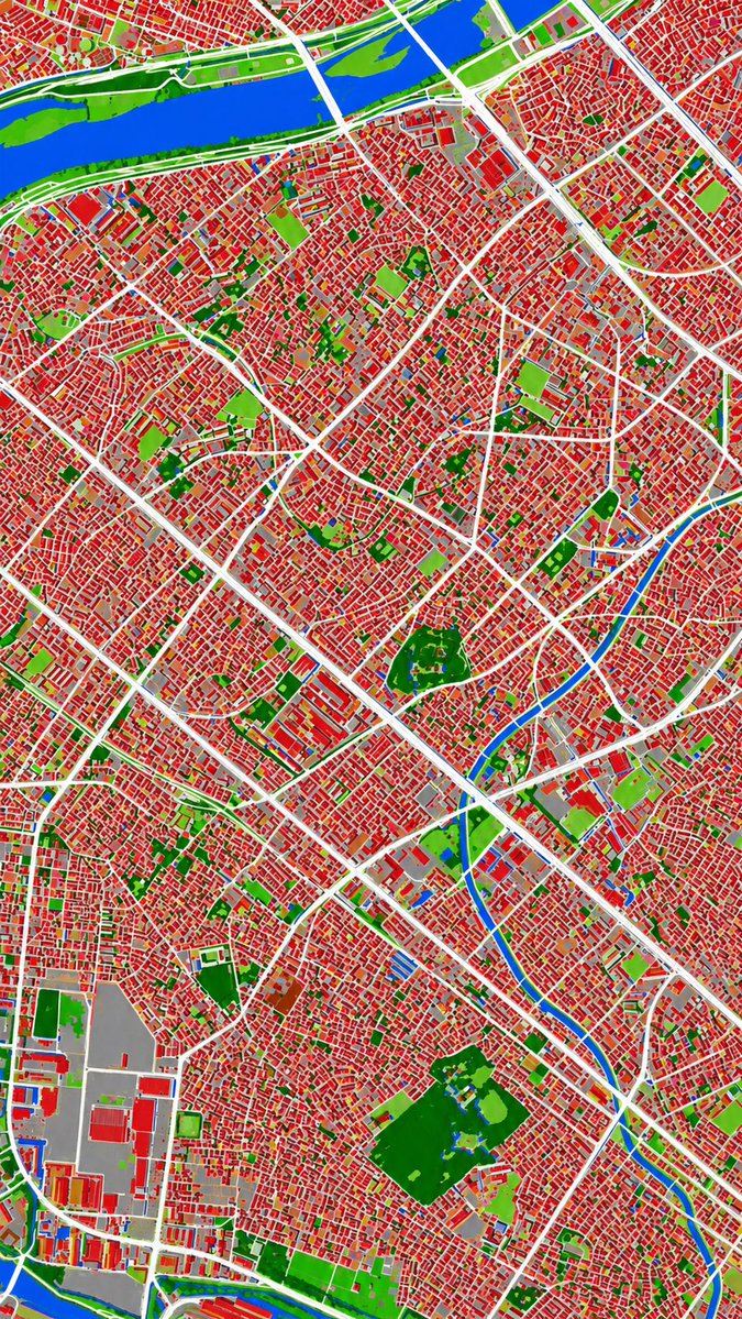
Aerial Photo to Land-Cover Map
This prompt converts a reference aerial photograph into a false-color land-cover classification map for urban analysis or map-style visualization.
図解、チェックリスト、ロードマップ、学習用長図に向いています。情報階層を先に決め、画像内テキストは短くすると安定します。
推奨比率
16:9 または 4:3
品質の進め方
まず軽く生成し、良い案を高精細で詰める
生成フロー
参考画像や既存レイアウトに合わせたい場合は画像から画像を使い、それ以外はテキスト生成で方向性を固めます。
Qwen Image 完全プロンプト
English prompt
Using REFERENCE_0 as the source geography and urban layout, transform the monochrome historical aerial photo into a clean land-cover classification map using the false-color visual language implied by REFERENCE_1. Keep the same top-down viewpoint and street/block structure, but replace photographic texture with flat segmented regions and crisp boundaries. Classify the scene into exactly 6 visual categories: 1) buildings as red, 2) roads and major paved corridors as white, 3) water bodies and canals as blue, 4) dense vegetation/parks as dark green, 5) open grass or sparse green areas as light green, and 6) industrial or large paved/open facility areas as gray. Produce a dense urban thematic map with strong contrast, minimal shading, and no labels, legends, borders, or photographic film markings.
関連するQwen Imageプロンプト
VR Headset Exploded View Poster
Generates a high-tech exploded view diagram of a VR headset with detailed component callouts and promotional text.
Illustrated City Food Map
Generates a hand-drawn, watercolor-style tourist map featuring numbered local food specialties, landmarks, and a legend.
3D Stone Staircase Evolution Infographic
Transforms a flat evolutionary timeline into a realistic 3D stone staircase infographic with detailed organism renders and structured side panels.
Momotaro Explainer Slide in Hybrid Style
A prompt that combines the simple, warm aesthetic of simple illustration style illustrations with the high-information density characteristic of Japanese government slides.
Faceless Cyberpunk Infiltrator
Generates a cinematic anime scene of an armed faceless woman infiltrating a high-security futuristic server room.
Pancake Angel Cafe Cover
Generates a dreamy watercolor anime cover of a winged cafe angel serving honey pancakes in a sunlit morning cafe.